The Ayeyarwady River is approximately 2170 km long with a 414,000 km2 catchment area occupying 62% of the country. The usage of the basin’s water is still limited compared to other large river basins in the region, so it’s important to carefully plan basin developments before development implementation to minimise adverse impacts.
Developing a planning tool for the river basin
The objective of the DSS tool is to help Myanmar officials make informed decisions that would sustainably develop the Ayeyarwady River basin. The tool can also help officials inform stakeholders about the benefits and impacts of development scenarios and engage them in the decision process.
Using Ayeyarwady River basin-specific data, DHI developed the multipurpose decision support tool.
The tool can support integrated water resources analyses, planning and management. Specifically, it can help assess the consequences of various river basin development scenarios. Development scenarios included different combinations of hydropower dams, irrigation schemes, changes in land cover and forecasted climate change. The corresponding changes in sea water intrusion, sediment transport and flooding were also assessed.
Supporting data-backed decision-making
The DSS converts the results of different models and scenarios into a range of environmental, social and economic indicators. These indicators highlight the consequences of possible basin development activities. Such insights make it easier for authorities and other stakeholders to assess and compare development options. For example, the DSS showed how hydropower—which potentially can be increased tenfold —would affect navigation, sediment transport and other water use in the basin. It can also illustrate the spatial distribution of predicted benefits and impacts, as seen in the image below.
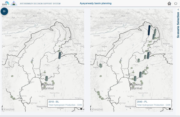
DSS comparison of power production and its geographical distribution in two scenarios
More than a planning tool
The DSS also includes a comprehensive database, access to near-real-time Earth Observation data, and a library of relevant papers and reports. Accompanying these assets, DHI provided special training to local users to ensure the system’s continued use.
For more about this project, check out the full case story here
Helping meet Sustainable Development Goals
In addition to helping local development goals, such a DSS can potentially help water authorities around the world to meet Goal 6 of the United Nations (UN) 17 Sustainable Development Goals (SDGs), concerning access to water and sanitation for all. Specifically, this river basin DSS can help officials meet the following subgoals:
- 6.5 — By 2030, implement integrated water resources management at all levels, including through transboundary cooperation as appropriate.
- 6.6 — By 2020, protect and restore water-related ecosystems, including mountains, forests, wetlands, rivers, aquifers and lakes.
All United Nations Member States, including Myanmar, adopted the 2030 Agenda for Sustainable Development in 2015.
About the National Water Resources Committee and the Hydro-Informatics Centre
The National Water Resources Committee (NWRC), part of the Myanmar water sector, aims to promote good water governance and implement integrated water resource management (IWRM) across the country. As such, they have partnered with the World Bank to create the Ayeyarwady Integrated River Basin Management (AIRBM) project. The Focal Ministry of NWRC is the Union Ministry of Transport and Communications (MOTC) and the implementing agency is the Directorate of Water Resources and Improvement of River Systems (DWIR).
One of the major outputs of the AIRBM project is the development of a Decision Support System (DSS) and the Ayeyarwady Basin Master Plan. The formulation and analyses of various river basin development scenarios were represented in the DSS development by the Hydro-Informatics Centre (HIC). HIC was established in 2014 as a water operation centre and decision-support arm of the NWRC for water resources development and management in Myanmar.
For further information, contact:
Oluf Zeilund Jessen
Head of Department
Water Resources Department
ozj@dhigroup.com
Hans Christian Ammentorp
Team Leader AIRBM C1.17
Water Resources Department
hca@dhigroup.com