We conduct a rapid simulation of a massive earthquake in the Solomon Islands
On 6 February 2013 at 12:12 local time (1:12 UTC), several seismologic stations around the world recorded an MW=8.0 earthquake near Santa Cruz Island (Solomon Islands) in the South Pacific.
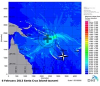
On 6 February 2013 at 12:12 local time (1:12 UTC), several seismologic stations around the world recorded an MW=8.0 earthquake near Santa Cruz Island (Solomon Islands) in the South Pacific. We conducted a rapid simulation of the earthquake, based on the first moment tensor solutions of USGS and GFZ.
The result of our simulation reveals that Solomon Islands are affected. The earthquake has especially affected the eastern Islands like San Cristobal, Guadalcanal and Greenwich Islands, located in close vicinity of the earthquake. Small waves also arrived at Vanuatu and the Northern coasts of New Caledonia and Fiji Islands. Although Australia’s Gold Coast is mostly protected by the Great Barrier Reef, our results show that Cairns might experience slight water disturbances.
The earthquake occurred at the subduction zone, where the Pacific plate and the Australian plate move against each other. Subduction occurs at convergent boundaries. During this process, one tectonic plate moves under another and sinks into the earth’s mantle as the plates meet. These regions are called subduction zones.
A tsunami warning has been issued for the region. At 13:48 local time (2:48 UTC), the emergency authorities on Santa Cruz Island reported that a tsunami has destroyed three villages on the island. The warning has later been extended to include Australia and New Zealand, and now being canceled. Evacuations have already been carried out in New Caledonia.
Read more